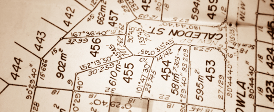
Zoning questions? Here’s how we can help…

Is my property subdividable?
Can I start a home-based business here?
Are there height restrictions?
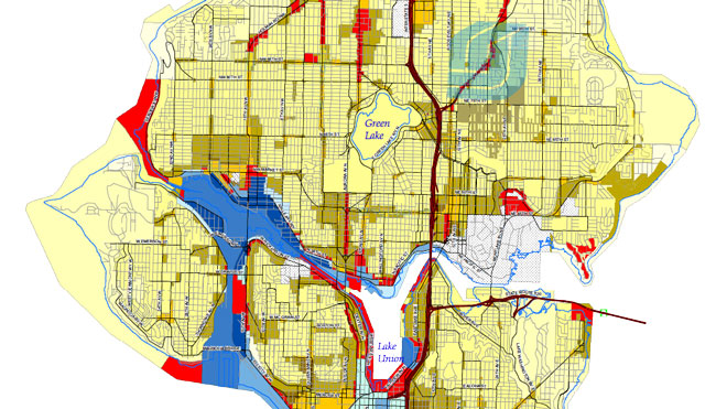
Zoning Map Example - Seattle

Buyers or sellers may ask questions like the ones above. The answers may often be found deep in the zoning code for a particular neighborhood or parcel.

Verify zoning jurisdiction

When questions about land use or zoning come in to our Ticor Title Customer Service team, the first thing we’ll do is verify which jurisdiction the property is in. This is important because zoning can be under the jurisdiction of a city or the entire county. There’s no point in calling Pierce County Planning and Land Services if the property is inside the city limits of Tacoma and vice versa.

To make matters more complicated, the same zoning code designation could be used by more than one city, and it could mean different things in different jurisdictions. (For example, R-4 in the city of Bellevue has a minimum lot width of 65’ while in Covington the minimum lot width is 30’. Setbacks, minimum dimensions, and height restrictions may be very different from city to city, even if they use some of the same codes.)

Your Ticor Title customer service team can help connect  you with  the right department where an engineer or technician will be able to answer your client’s questions with authority!

Connect with the right department

Click the image to download a printable version of this article.

It’s important to get the facts. Your client may be basing important decisions on the answers to their questions.  Zoning and related issues are subject to changes due to annexations and/or changing regulations. You or your client will want the most current and direct information possible. Your Ticor Title customer service team can help connect you with the right department where an engineer or technician will be able to answer your client’s questions with authority!

In some cases, the zoning classification may not be exactly what you or your client was hoping for. Fear not. There may be options. Check with the jurisdiction to see if they might allow a variance for a specific parcel. If all the neighbors in an area agree, it may also be possible to request a rezone that would affect a whole block or neighborhood. (Link to Map 1) In cases where the surrounding zoning is all like-kind, it may be harder to get a variance or rezone than if the neighborhood is a patchwork of different zoning codes.

King, Pierce, and Snohomish zoning resources

Consider CC&R’s

In addition to zoning regulations, another possible factor to consider may be CC&Rs. A change that fits within the current zoning code regulations may be prohibited by a property’s CC&Rs. For example, a property that is zoned SF 5000 in the City of Seattle may have maximum height of 30’ in the zoning code but the same property may also have a recorded view easement or plat covenants that limit homes on the lot to a single story. When the various regulations conflict, the rule of thumb would be to abide by the most restrictive among them.

To see the unincorporated county zoning on a map, check out these great sites:

Often cities will provide mapped zoning information as well, often in a PDF format. Here are a few examples:

Often cities will provide mapped zoning information as well, often in a PDF format. Here is a link to a great site with links to city web sites and municipal codes:  http://www.mrsc.org/codes.aspx

Be thorough in your research

As with many property issues, there’s more to than story than meets the eye. The information provided by your title company is usually just the tip of the iceberg. Buyers and sellers should always perform  thorough research before making any big plans or decisions. In fact, it might be a good idea to consult with a land use attorney.
Do you have thoughts or questions? Please share by commenting below!

Real Estate Legal Descriptions in Plain English

Legal descriptions of property, those all-important components of a Purchase and Sale Agreement, fall into two basic categories: platted and unplatted properties. Of course, there are many variations in each category! For your reference, we have put together a quick reference with examples below.

Click on any link below to see examples of various types of legal descriptions & the maps that go with them.

Platted is a general term for properties where a subdivision involving an approved survey map and plans that describe each lot or unit and that are recorded with the county. Subdivisions, shortplats, and even condominiums are under this umbrella. The “description” part of the legal description is a sort of shorthand that provides location and dimensions by referring you to a specific parcel on the recorded map.

  • Subdivisions often have “Lot and Block” legal descriptions which reference one or more lot numbers, sometimes a block number, the subdivision name plus the volume and page that it was recorded under in County records. In some cases the legal description may reference a recording number rather than volume and page – this is common with newer plats in Pierce and Snohomish counties. Click here to view an example of  a Lot & Block Map.

Example of a Lot & Block Legal Description

  • Shortplats usually involve fewer lots than a full subdivision (or “long plat”). The legal for a shortplat will typically involve a lot number or letter, and the recording number. Often it will include the city or county planning department’s file number as well.  Click Here to view an example of a Shortplat Map.

Example of a Shortplat Legal Description

  • Condominium legals reference Unit number, sometimes a Building number, and the subdivision name with the volume and page that it was recorded under in County records plus the Condo Declaration Recording Number.  Click here for an example of a Condominium Map.

Example of a Condominium Legal Description

Unplatted refers to all the other lots that don’t have an approved plat recorded. (It’s never a perfect world so there may be some exceptions to this rule.) These legal descriptions are all about location and dimensions.

  • Unplatted legals typically reference the Section, Township and Range that the lot is located in, plus quarter-section and sometimes a whole series of quarter-quarter details. These numbers refer to the public land survey system that covers the whole country into square-mile Sections. They allow us to pinpoint the exact location of a lot. Click here for an example of an Unplatted Parcel Map.

Example of an Unplatted Legal Description

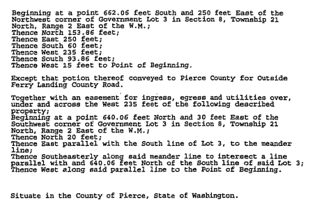
  • Unplatted legals may take the form of metes and bounds (distances or dimensions from point to point that literally describe the lot).  Click here for an example of an Unplatted Parcel Map as described with Metes & Bounds.
Example of a Metes & Bounds Legal Description

Example of a Metes & Bounds Legal Description

  • Finally there may be references to other features (shorelines, roads, existing plats just to name a few) that may help to identify location or dimensions.

If you have questions regarding a legal description on your purchase and sale agreement, our property information specialists are prepared to assist.

If you have questions or comments, let us know by commenting below.  Or Contact us today at 425-255-6969!

Also, please click to view our related article: What Makes a Real Estate Description “Legal”?

Behind the Scenes: A Video Tour of our History-Filled Backplant

Ticor Backplant Pierce County WA
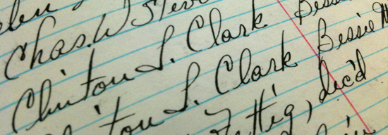
[Note: Our Renton office has relocated to Columbia Center, Downtown Seattle]These days, most of the real estate property research our title examiners and customer service team does for you involves sophisticated online databases and image libraries using up-to-the-minute technology. But occasionally we rely on a much older technology as we research the chain of title for real properties in King, Pierce, and Snohomish, WA.

Since the early 1980s, recorded documents have been compiled into searchable databases. We can search by legal description or by name to find deeds, easements, and other public-record information. Most documents recorded since 1990 have also been imaged, so we can usually send you legible copies of recent documents very quickly.

However, sometimes we need documents that are too old to be found in these more recent databases. For those, we turn to our backplant. Backplants are a series of log books that show all recordings in a county. Our records go back to the mid-1800s. Depending on the county, these logs may be on microfilm or may be large hand-written books.

As you can see in the backplant video tour below, the hand-drawn maps and fine penmanship evoke feelings of appreciation for the care, skill, and artfulness of the many people that crafted and maintained these books so many years ago.


What is a Plat? And what should I know as a home buyer?

What is a plat?

A plat is another name for a subdivision. For example, Fircrest is a well known city of about 6,000 near Tacoma. Residents know that Fircrest is not just one neighborhood, but a combination of many unique, smaller communities. And usually, these neighborhoods are named from a subdivision, or plat, that defines the land within a specific area. So, Fircrest residents may think of their particular neighborhood as Fir Tree Park, Linden Manor, Regents Park, or Monterey Park. Each of these ‘neighborhoods’ started as a ‘plat’ or ‘subdivision.’

Seeing a copy of the plat is important because it provides information that may not be recorded anywhere else. Often ‘the plat’ provides specific locations of lots and other features in a visual way on the survey map. Seeing an easement drawn on a map is easier for most of us to understand than reading the legal description would be. Also, a plat creates simple and logical legal descriptions for lots which are far less prone to error or misinterpretation than are metes and bounds legals.

Plat Map Markers

Click to Download the Interactive Plat Map

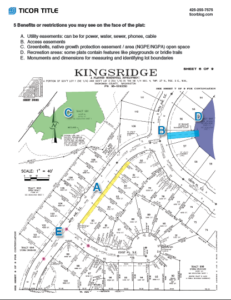
5 benefits or restrictions you may see on the face of the plat (download interactive map):

  1. Utility easements: can be for power, water, sewer, phones, cable
  2. Access easements
  3. Greenbelts, Native Growth Protection Easement/Area (NGPE/NGPA) open space
  4. Recreation areas: some plats contain features like playgrounds or bridle trails
  5. Monuments and dimensions for measuring and identifying lot boundaries

The notes section or the map may contain valuable information about:

  • Who is responsible for maintenance of common areas
  • Who can use specific tracts and for what purpose
  • Which tracts will remain as greenbelts and which are designated for future development

Do you have questions about a particular plat? Need some help, understanding some of the important items on a plat? Ticor Property Information Specialists are at your service!

Click here to download the interactive plat map.

Ticor Email for Property Info: cs.wa@ticortitle.com
Ticor Seattle / Renton: 206-720-6969 / 425-255-6969
Ticor Bellevue: 425-467-0377
Ticor Puyallup / Pierce County: 253-383-0055
Ticor International: 425-204-5113

Note: Some charges may apply, in accordance with Washington State Insurance Commissioner Guidelines, but profile, map and deed are always free.

*Correction 4-26-2011 – Fircrest is a city near Tacoma, not a neighborhood in Tacoma.

6 Tips for Reading Plat Maps

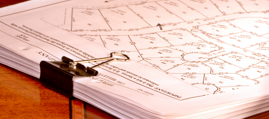
how to read a plat map

Each day, most real estate professionals access ‘Plat Maps.’ The need for these maps varies for each property, and each circumstance.  In Ticor’s effort to make things easy for clients, we thought you could use some ‘Pointers’ about working with Plat Maps!

6 Tips for Reading Plat Maps:

1.  Access –  Access is simply how someone can physically reach the property.  We have a sample for you here, where you can see that ‘Access’ is shown on map, by

A. city or county road,
B. private driveway (flagpole lot),
C. shared driveway with common ownership,
D. shared driveway with easement, and
E. private road.

Click the map to view an explanation of types of access

2. Views – Ticor usually provides a ‘Close –up’ view of the lot, along with a larger view.  Viewing the larger view will help you identify important points, such as where your lot is located, in relation to a major thoroughfare, or greenbelt.

3.  Dimensions – These are usually given for the lot as shown, but there can be variances.  But, what if no Dimensions are showing?

Places to check further for ‘Dimensions,’ are always available thru Ticor Property Info.  For example, Ticor Property Info Specialists can give you a copy of the ‘Face of the Plat’ if available; or can provide approximate dimensions with a map measuring tool.

4.   Unplatted, or Platted Property – Platted Property is created by the developer recording a plat. Unplatted parcels are not  in a recorded subdivision. Platted  land often has “lot and block” legal descriptions, and unplatted usually has “metes and bounds” legals. Of course, there are exceptions to every rule! For platted parcels, we can look at the face of the plat for a wealth of information about the lot and its surroundings. We’ll address this in depth soon, here at TicorBlog.com.

5.  Location of Lot – As it relates to a block, always useful to know. We’ll address this more in a future article.  In the meantime, it is always wise to check where your subject property ‘sits’ on a block, based on what you’ve seen, vs. what is showing on your Plat Map. Are these different? If so, it’s time to ask for some help from Ticor!  You can also compare the lot size to the acreage or lot square feet given on the property profile.

6. Troubleshooting Plat Maps – Don’t assume boundary lines, based on what is showing on a Plat Map. While Plat Maps can give a good idea as do the location of these lines, the only definitive way to know exact boundary lines is thru a survey.

One last note:  Remember, King County’s Plat Maps display information a bit differently than Snohomish or Pierce County.

Our Property Information Specialists are at your service!

Ticor Email for Property Info:   cs.wa@ticortitle.com

Ticor Seattle / Renton:
Ticor Bellevue:
Ticor Puyallup / Pierce County:
Ticor International:
206-720-6969 / 425-255-6969
425-467-0377
253-383-0055
425-204-5113
Note: Some charges may apply, in accordance with Washington State Insurance Commissioner Guidelines, but profile, map and deed are always free

Do you have questions, comments, or tips that you would like to share regarding plat maps? Please share your thoughts, questions, or comments below!

Property Information on demand saves the day

Real Estate Buyer

Click the image to download “5 Reasons to Order a Trio”

Having the right property information at the right time can sometimes make or break a sale.  At Ticor, we live and breathe property information.  It’s our job to examine every parcel in the Puget Sound area that we insure to know how it’s described, who has a claim to it, and how it may be used. And naturally this area of expertise becomes invaluable when a Real Estate agent needs information fast. Below is a true story that took place in December:

Right around December 16th, most of us were occupied with Holiday prep and planning.  But for Shawn L., it was a good day to handle a sign call.  Shawn had moved to a new brokerage in West Seattle a few months earlier, and he had several listings on the market.

‘Tell me about your listing,’ said the client.  This buyer was interested in a home that Shawn had listed in Seattle’s Central District, and phoned around 2 pm to ask about a showing.  And the buyer had several questions, most of which were easy to answer immediately. But, when the buyer asked ‘How much are property taxes for this home?,’  Shawn had to get help fast.  So, on the way to his showing appointment, he called Julie McCullough Hale with Ticor.

‘Can you get me property taxes for this address?’ asked Shawn.

‘Yes!  How about a property profile, legal description, and a plat map too?’ said Julie.

‘That would be awesome!’ replied Shawn.

And in 20 minutes, Shawn had all of this info at his fingertips, delivered to his iPhone.

Ticor sends free property information to our customers every day. What Shawn received on his phone was called a ‘Trio’ (Property Profile, Map, and Deed with Legal Description).  This is also called a ‘Listing Packet.’

Often, agents order title work at the time of listing a property, and Ticor always confirms this with an order number, and a ‘Free Trio.’  And even though it’s something that goes out dozens of times every day, our Property Info staff knows that every request is critically important to whoever contacts us.  In Shawn’s case, he needed his info on the run, since he was driving to meet a client.  He didn’t have time to personally research. So, he called the people he knew he could count on for accuracy and a fast turn around.

So, what happened with Shawn’s prospect?  Later that day, Shawn made another call to Julie with Ticor.

‘How quickly can we close for a cash buyer? I think he’d like to do so before Christmas.’

Property Information sent to your smartphone

Property Information sent to your smartphone

Julie let him know that with a clear title report, and a cash buyer, it was quite likely that closing could be completed within a week.  The next morning, his office called Ticor Escrow for an earnest money pick up.  And the best part – this transaction closed in under a week.  A nice end to a busy year for Shawn and his office.

‘We’re reminded every day how important our Property Info Services are,’ said Ryan Kalalau, Ticor Sales Manager.  ‘Getting the right info delivered quickly, is one of the most important services we offer.’

Thanks to:  Shawn L., West Seattle agent

Here’s a link where you can order your own ‘Free Trio’ right now!

Order free Ticor Trio HERE

Ticor Seattle / Renton:  206-720-6969 / 425-255-6969
Ticor Bellevue:  425-467-0377
Ticor Puyallup / Pierce County:  253-383-0055
Ticor International:  425-204-5113
Ticor Email for Property Info:   cs.wa@ticortitle.com

Download “5 reasons to order a trio” here

Do you have a story about how having the right information at the right time made the difference between winning and losing a deal? Please leave a comment below!

Delegate These 5 Tasks & Save Time With Every Real Estate Transaction

Ticor’s customer service / property research team is well known in the Puget Sound area for their depth of knowledge and high level of service to local Real Estate professionals. They are the best of the best when it comes to providing property information with a smile.  And while our customer service team is doing what they do best, they’re also saving our clients the most valuable resource they have which is time.

How many times have you thought, “If I just had more time…” Would your own personal Property Research Assistant help?  Experienced real estate professionals are experts at leveraging their most valuable skills for the most profit.  And our most successful clients tell us that working with the Property Info professionals at Ticor Title Company, really saves them time.  Below is a brief list of things our team can do for you so you can focus your time on what brings you the most profit.

Delegate these 5 tasks to Ticor’s customer service team & save time:

  1. Pre-Listing Pack or ‘Trio’: Profile, map, and deed with legal description
  2. Check Owner’s Name(s) or find a phone number
  3. Mailing list & labels around a new Listing
  4. Tax assessed value
  5. Plat map with dimensions

Ticor has a dedicated Team of ‘Property Info’ professionals, who will find these answers for you.   Next time you need to do some research, delegate it to Ticor!
Serving:

King & Snohomish County

Diane Brittenham
Anne Serex
Susan Barney
425-255-6969
425-467-0377
206-720-6969

Pierce County

Rachel  Jacobson
(253) 383-0055

Emerging Markets

Mandy Quach
(206) 720-6969

(Outside of these counties too!)
CS.WA@TicorTitle.com

Save Time on every real estate transaction

Save Time on Every Real Estate Transaction with Ticor Customer Service

Click the image to the left for a sample list of services from Ticor’s Customer Service / Property Info Team