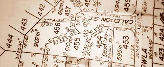
Each day, most real estate professionals access ‘Plat Maps.’ The need for these maps varies for each property, and each circumstance. In Ticor’s effort to make things easy for clients, we thought you could use some ‘Pointers’ about working with Plat Maps!
6 Tips for Reading Plat Maps:
1. Access – Access is simply how someone can physically reach the property. We have a sample for you here, where you can see that ‘Access’ is shown on map, by
A. city or county road,
B. private driveway (flagpole lot),
C. shared driveway with common ownership,
D. shared driveway with easement, and
E. private road.
2. Views – Ticor usually provides a ‘Close –up’ view of the lot, along with a larger view. Viewing the larger view will help you identify important points, such as where your lot is located, in relation to a major thoroughfare, or greenbelt.
3. Dimensions – These are usually given for the lot as shown, but there can be variances. But, what if no Dimensions are showing?
Places to check further for ‘Dimensions,’ are always available thru Ticor Property Info. For example, Ticor Property Info Specialists can give you a copy of the ‘Face of the Plat’ if available; or can provide approximate dimensions with a map measuring tool.
4. Unplatted, or Platted Property – Platted Property is created by the developer recording a plat. Unplatted parcels are not in a recorded subdivision. Platted land often has “lot and block” legal descriptions, and unplatted usually has “metes and bounds” legals. Of course, there are exceptions to every rule! For platted parcels, we can look at the face of the plat for a wealth of information about the lot and its surroundings. We’ll address this in depth soon, here at TicorBlog.com.
5. Location of Lot – As it relates to a block, always useful to know. We’ll address this more in a future article. In the meantime, it is always wise to check where your subject property ‘sits’ on a block, based on what you’ve seen, vs. what is showing on your Plat Map. Are these different? If so, it’s time to ask for some help from Ticor! You can also compare the lot size to the acreage or lot square feet given on the property profile.
6. Troubleshooting Plat Maps – Don’t assume boundary lines, based on what is showing on a Plat Map. While Plat Maps can give a good idea as do the location of these lines, the only definitive way to know exact boundary lines is thru a survey.
One last note: Remember, King County’s Plat Maps display information a bit differently than Snohomish or Pierce County.
Our Property Information Specialists are at your service!
Ticor Email for Property Info: cs.wa@ticortitle.com
| Ticor Seattle / Renton: Ticor Bellevue: Ticor Puyallup / Pierce County: Ticor International: |
206-720-6969 / 425-255-6969 425-467-0377 253-383-0055 425-204-5113 |
Do you have questions, comments, or tips that you would like to share regarding plat maps? Please share your thoughts, questions, or comments below!

